


Liaison - Noirefontaine - Dohan - Cugnon - Bertrix (Liaison - Noirefontaine - Dohan - Cugnon - Bertrix )
À Botassart
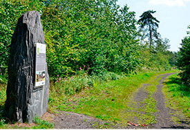
A - The Giant’s Tomb Voir sur la carte
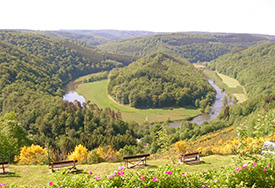
Botassart, a village near Bouillon, is the scene of one of the loveliest, most majestic panoramas in the Ardennes. Here, the Semois makes the most of the relief, constantly winding back and forth. The loop it forms in Botassart is so tight that an island is born in the heart of this green ocean, creating the formidable tomb of a giant said to have been struck down here.
Toerist information desk of Section locale du RSI de Bouillon
rue de Châteaumont
site du point de vue - 6833 Botassart
+32 (0)61/46.00.76
sibotassart@gmail.com
Did you know? Voir sur la carte
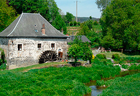
A ford enabled travellers, pedlars or soldiers of the time to cross the Semois and reach Bouillon. Opposite the mill stands the Hermit’s Rock (la Roche de l’Ermite). A hearth created in the rock provided shelter for a hermit-weaver in the late 17th century.
À Cugnon
B - Walking Voir sur la carte
The Mill and the trellis bridge
Walking in the Semois valley when spring comes is delightful! The banks of the river are scattered with thousands of flowers. On the way to the bridge lies the beautiful Mortehan mill: at dawn, its wheel still stirs the waters of the race. Down below, the Semois valley lazily criss-crosses a vast meadow, rich in the river’s alluvial deposits. With the beginnings of warm weather, we can cross the Semois ford on foot, once the only way for the people of the valley’s villages. In season, a trellis bridge is thrown across the water. On the other side, a delightful route ascends the slope. The forest is majestic, as are all the massifs that encircle the Semois.
Practical details
Distance: 9 km
Waymarking: walk No C1.
Difficulty: average
Time: 3 hrs
Start: from Cugnon, go towards Mortehan.
The walking map 'Auby - Cugnon - Mortehan - Bertrix - Herbeumont - Saint-Mard - Straimont' is available in the following tourist centers :
- Maison du tourisme du Pays de Bouillon
Tel: +32 (0) 61/46.52.11
Email : info@bouillon-tourisme.be
- Syndicat d'initiative de Bertrix-Semois
Tel: +32 (0) 61/41.43.92
Email : sibertrix@skynet.be
- Syndicat d'initiative de Bertrix-Semois
Tel: +32 (0) 61/41.24.40
Email : sicugnonx@skynet.be
- Syndicat d'initiative d'Herbeumont
Tel: +32 (0) 61/41.24.12
Email : rsih@skynet.be
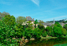
À Mortehan
C - The Fairies’ Castle Voir sur la carte
Visitors enter the fortress along a corridor. The thick terrace walls command respect. In the Middle Ages, a keep 18 metres high and 13 metres wide dominated this highly strategic location. Encircled by the Munos and Monceux streams, these days it holds out the promise of a lovely walk…
From the fortress, a very pretty walk follows the course of the two streams. (Walking map on sale at the Tourist Office)
Access: The castle is on the Mortehan-Bertrix road.
À Mortehan
D - The old cemetery Voir sur la carte
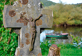
It is sometimes difficult to describe the feelings aroused by sites like these. The old cemetery in Mortehan carries visitors into another world. The tombstones bewitch us in the early hours, when vapours rise from the Semois and pervade the area.
Access: The cemetery is hidden from the view of the living. At the little church, follow the road that goes down towards the river. The cemetery lies behind the shale houses.
À Bertrix
E - Walking
The Way of the Speaking Stones
The disused Bertrix-Herbeumont-Muno line was built between 1902 and 1914. It does not include any level crossings, just tunnels and viaducts. The line was used by the Germans during World War One to supply their troops as far as Verdun... The portion of the line from Bertrix to Herbeumont has now become a pleasant walk, the ‘Way of the Speaking Stones’. Along the route, informative panels describe the riches of the Bertrix region acquired thanks to the slate industry. The walk starts at the esplanade of the old station.
À Bertrix
F - At the heart of the slate Voir sur la carte
Equipped with helmets and audio guides, visitors are ready for an amazing journey into the bowels of the earth. The atmosphere in this old slate mine is captivating. Visitors are immersed in the world of those courageous miners of yesteryear. During the descent, they learn about the techniques used to extract this black stone, which was to be used in many buildings, including a number of abbeys. Emerging from this dark universe, they can well imagine the joy felt by the labourers when they saw daylight again after a hard day’s work.
Our favourite: the gourmet mine, where a meal is served at a depth of 25 metres underground!
rue du Babinay, 1
6880 Bertrix
Tel : 0032(0) 61 41 45 21
Web : www.aucoeurdelardoise.be
À Dohan
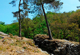
G - A border rock
A highly strategic place in the Middle Ages. At the time, the castle kept watch over the ford, an alternative for those wishing to avoid the powerful lords of Bouillon.
Did you know?
In the Middle Ages, the ‘Roche Percée’, a natural site where a path runs alongside the river, was the border between the Duchies of Bouillon and Luxembourg, upstream of the mouth of the Alleines stream. The site, which is mentioned in a medieval treaty, also set the boundaries of the bishoprics of Reims, Trêves and Liège.
Walking
It is possible to reach the ‘Roche Percée’ following the path that runs along the Semois, just beyond the ‘Poteau de Léveau’. A narrow path from the rock takes you to a splendid panoramic view.
Practical details
Distance: 6 km
Waymarking: red diamond, walk No 40.
Difficulty: average
Time: 2 hrs
Start: opposite the church, go up the steps towards the roadside cross.
À Cugnon
H - Reception and tourist information site : Voir sur la carte
Le Syndicat d’initiative de Bertrix-Semois, place de Cugnon , near the church
À Bertrix
I - Tourist reception site Voir sur la carte
Syndicat d’Initiative de Bertrix
place des Trois Fers, 12 - 6880 Bertrix
+32 (0)61/41.43.92
sibertrix@skynet.be
Open :
In July and August from Monday to Saturday from 10am tot 5pm
During the rest of the year, open everyday except on Sunday, variable schedule (closed from midday to 1.30pm)


