


Rouvroy-sur-Audry
À Thiérache
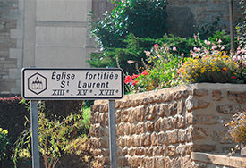
A - The fortified churches Voir sur la carte
1650. The dreadful Hundred Years’ War was merciless for Thiérache: armed hordes from the Spanish Netherlands swept in from the marshy plateau, destroying all that stood in their way. In the open countryside, the people had to rely on themselves for their protection: the lord’s castle was far away. So they fortified, either the cemetery or the church. They reinforced the nave, they filled in the windows and the door was moved to the side, where it was far easier to protect. The church became a stronghold able to withstand these armed bands.
Did you know?
A route along roads runs through the lovely Thiérache region, encountering fortified churches along the way: it is waymarked using hexagonal panels. The roads, magnificent and quiet, are truly superb for cyclists. Bicycle tourists will be in seventh heaven.
À Rouvroy-sur-Audry
B - Walking Voir sur la carte
Servion church
The fortified church of Servion looks more like a fortified castle than a place of worship! The towers, blockhouses and arrow slits were designed to dissuade the bands of rough soldiers!
A short, very pleasant walk criss-crosses the area around the church, which has been converted into a cultural centre.
Practical details
Distance: 3 km
Waymarking: follow the yellow signs
Difficulty: easy, pay attention to the waymarking
Time: 1 h
Start: behind the church, where a wooden panel describes the route.
To go further afield…
Topo guide, Les Ardennes à pied (The Ardennes on foot), published by the French Hiking Federation. Walk No 1 (the ‘Boulette’ circuit).
À Remilly-les-Pothées
C - Remilly-les-Pothées Voir sur la carte
The castle, like the church, is built like a rock, ready to withstand the attack of mercenaries or Huguenot fanatics from the north. Robust structures that were able to hold out for two or three days, but not when faced with artillery. Luckily for the villagers, these bands were usually equipped with light weapons.
Tip
The walk goes to Rouvroy-sur-Audry and rises towards the ridge dominated by the tree of Peace. The panoramic view is superb, revealing one of the most beautiful landscapes in the wooded Ardennes.
Practical details
Distance: 6.5 km
Waymarking: follow pink signs
Difficulty: easy, pay attention to the waymarking
Time: 1.30 h
Start: as you leave Servion, start from a street on the left, just after the path on the right leading to the fortified church.
To go further afield
Topo guide, hikes on the Rocroi plateau and in the Ardennes Thiérache region (Walk No 27).


